BUY CRIME POSTCODE DATASETS.
Buy your own complete up to date database of 1.6 million postcodes (England, Wales and Northern Ireland - not Scotland) matched to crime within different radiuses so you can instantly make comparisons. All postcodes with crime totals, crime rates and percentile ranking (0 is lowest, 100 is highest) by all crime and 16 different crime categories. View sample data here. Look at the latest 12 months or compare previous calendar years; 2023, 2022, 2021, 2020 and 2019.
UKCrimestats.com is a proven, public-facing, trusted source used by academics, the media, insurance companies and underwriters in the City of London. For any questions or queries, contact us on crime@economicpolicycentre.com or Dan Lewis direct on +44(0)7900 245 306.
N.B. - these are very large files, running to hundreds of megabytes that can't be emailed - after purchasing the data you will be able to immediately download them from your browser.
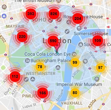
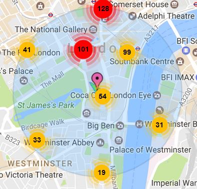
Below are crime maps of what a 1, 0.5 and 0.25 mile radius looks like around the postcode for 10 Downing Street in London, SW1A 2AA.
_______________________________________________________________________Postcode 1 mile radius percentiles
 |
Most Recent Year £299 including VAT - view sample data. These files are updated once a month with the latest postcodes and crime over the last 12 months. To download
Latest 12 Months: £299 2023 January - December: £150 2022 January - December: £99 2021 January - December: £49 2020 January - December: £49 Secure payments via Stripe. Immediate download of 1 mile radius zipped csv file after online payment. |
____________________________________________Postcode 1/2 mile radius percentiles |
|
 |
Most Recent Year £299 including VAT - view sample data. To download
Latest 12 Months: £299 2023 January - December: £150 2022 January - December: £99 2021 January - December: £49 2020 January - December: £49 Secure payments via Stripe. Immediate download of 0.5 mile radius zipped csv file after online payment.
|
____________________________________________Postcode 1/4 mile radius |
|
 |
Most Recent Year £299 including VAT - view sample data. To download Latest 12 Months: £299 2023 January - December: £150 2022 January - December: £99 2021 January - December: £49 2020 January - December: £49 Secure payments via Stripe. Immediate download of 0.25 mile radius zipped csv file after online payment.
|
___________________________________________
Postcode 1, 0.5 and 0.25 mile radius percentiles
  |
Recommended deal - save over 40% - Most Recent Year £299 including VAT. These files are updated once a month with the latest postcodes and crime over the last 12 months.
Latest 12 Months: £499 2023 January - December: £199 2022 January - December: £149 2021 January - December: £99 2020 January - December: £99 Secure payments via Stripe. Immediate download of zip file containing 3 files of 0.25, 0.5 and 1 mile radius zipped csv files after online payment.
|
 |
UKCrimeStats.com was developed by the Economic Policy Centre Limited, Company Number 06985308, Unit 3 Cedar Court, 1 Royal Oak Yard, London SE1 3GA. |