Buy Postcode Report - £3.99
Do your due diligence, for a full overview spread over 16 pages, get your UKCrimeStats Postcode Report here for just £3.99. As used by Estate Agents, homebuyers, security companies and insurance professionals, this is the most comprehensive, up to date and incisive report available today. See our sample report here for the postcode LA1 1AD. Here is another more recent sample report from April 2024 for a typical urban area in London - N1 5TU over a 0.5 mile radius. If you're not sure which radius you want, we recommend small radius of 0.25 mile for very urban reas and large radius of 1 mile for rural and more remote areas. N.B. Big discounts available for buying multiple report credits, from 10% for 5 reports to 65% for 500. Annual unlimited reports also available.
- How does your selected postcode rank nationally for crime, over a 0.25, 0.5 or 1 mile radius?
- Where is crime happening and not happening in your area?
- What type of crimes tend to happen and not happen in your area?
- How many people live inside the radius of your postcode?
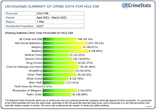
A UKCrimeStats postcode report answers these and many more questions, looking at 14 different crime types with a heatmap and statistics for all of these categories; Anti-Social Behaviour, Burglary, Robbery, Vehicle Crime, Violent Crime, Drug Crimes, Criminal Damage and Arson, Shoplifting, Other Theft, Bike Theft, Theft from the Person, Possession of Weapons and Public Order.